Flood · NH
By Jon Merwin, Founder and CEO
Published: October 14, 2026 · Updated: October 14, 2026
- FEMA has preliminary flood maps out for every Strafford County community, including Dover and Durham. As of October 14, 2026, they are not final.
- The 2015 maps still decide who has to carry flood insurance today.
- Once FEMA sends its final letter, towns get six months to adopt the maps.
- If your building moves into a high-risk zone, your lender will require flood insurance. FEMA’s Newly Mapped discount can soften the first years.
If you own a home in Dover, Durham or anywhere else in Strafford County, FEMA has redrawn your flood map, and the new version is close to final. As of October 14, 2026, the new maps haven’t taken effect, so nothing has changed yet for your mortgage or insurance. That window is the useful part: you can look up your property now, see whether its flood zone moves, and line up coverage before a lender letter shows up.

“New flood maps” sounds alarming, but the change goes property by property. Here’s how to find out whether yours is affected.
What is changing on the Dover and Durham flood maps?
The update is part of a larger FEMA project for the Piscataqua-Salmon Falls watershed, the rivers that drain toward Great Bay and the Piscataqua. According to New Hampshire’s floodplain management program, the project covers all or part of 26 inland communities in Rockingham and Strafford counties.
What that means for Strafford County owners:
- The Cocheco River, which runs through downtown Dover, gets revised engineering analysis in places, with new flood boundaries and elevations mapped from more detailed ground-elevation data.
- The Salmon Falls River along the Maine border, plus Bow Lake and several brooks, will have flood boundaries redrawn using that newer elevation data.
- Rough “Zone A” floodplains, the ones drawn without a flood elevation, are being remapped. The state notes that new Zone A areas may be added where flood risk isn’t shown on today’s maps.
Some lines will move, in both directions. In Durham, where the Oyster River runs down to Great Bay, and in Dover’s older neighborhoods near the Cocheco, it’s worth a look even if you’ve never thought of yourself as flood-prone. See our Dover insurance team and Durham insurance page for more local coverage help.
What about the Rockingham County side of the watershed?
Preliminary maps for the Rockingham County part of the watershed, including stretches of the Lamprey and Exeter rivers, came out December 12, 2024, per the state’s January 2025 Flood Lines newsletter. Coastal towns like Portsmouth and Rye aren’t part of this inland project.
Are the new flood maps final yet?
Not yet. Here is where the Strafford County maps stand, based on FEMA’s February 2026 announcement and the Federal Register notice:
| Date | Step | Status |
|---|---|---|
| September 27, 2024 | Preliminary maps issued for Strafford County (all jurisdictions) | Done |
| November 20, 2025 | Proposed flood hazard determinations published in the Federal Register | Done |
| January 20, 2026 | 90-day appeal and comment period begins | Done |
| Next | FEMA resolves appeals and comments, then sends each town a Letter of Final Determination | Pending as of Oct. 14, 2026 |
| Six months after that letter | New maps take effect, and towns must adopt them to stay in the National Flood Insurance Program | Pending |
Because of that six-month adoption period, the new maps can’t take effect until at least six months after FEMA’s final letter goes out. Until then, the effective 2015 Strafford County maps are the ones lenders use.
How do I check my property on the new map?
FEMA’s tools are open to the public, and you don’t need an account.
- Find your current zone. Go to the FEMA Flood Map Service Center, type your street address and note the zone shown for your building (for example X, A or AE).
- Open the preliminary map. Use FEMA’s Flood Map Changes Viewer to compare the effective map with the preliminary one for the same spot. Preliminary files are also on FEMA’s preliminary map download page.
- Compare the two. Did the shaded high-risk area move onto your building, off it, or stay put? If there’s a flood elevation, write it down.
- Call someone who can confirm it. Your town’s floodplain administrator can read the map with you, and FEMA map specialists answer at 1-877-336-2627.
One tip: zoom in. Flood lines often clip a back lot without touching the house, and what counts is where the building sits.
What does it mean if I’m newly mapped into a high-risk zone?
High-risk areas, which FEMA calls Special Flood Hazard Areas, are the zones starting with A or V. If the new map puts your building in one and you have a mortgage from a federally regulated or insured lender, FEMA’s Newly Mapped guidance says the lender will require flood insurance. Per FEMA’s Risk Rating 2.0 FAQ, lenders use the current effective map for that call and can require coverage outside high-risk zones too.
There’s some relief. If your building was in a low- or moderate-risk zone (B, C or X) and moves into a high-risk zone, FEMA offers a Newly Mapped discount that can lower first-year premiums for buildings newly mapped into a high-risk zone. You have to buy or renew within 12 months of the map change to get it. After that, the discount phases out gradually until the premium reaches the full-risk rate.

Look up your address on FEMA’s preliminary flood map now, not after the new maps take effect. If your home may be moving into a high-risk zone, putting a policy in place early can help you hold onto a lower rate through FEMA’s Newly Mapped discount, and we can quote both NFIP and private flood so you can compare.
— Jon Merwin, Founder and CEO
What to do now versus after the maps take effect
| If the preliminary map shows… | Before the maps are final | After they take effect |
|---|---|---|
| Your building moves into a high-risk zone | Look at coverage before the effective date so you’re in place within FEMA’s 12-month Newly Mapped window. Consider an elevation certificate. | Your lender will require flood insurance and should send a notice. |
| Your building moves out of a high-risk zone | Keep your policy. The current map still applies until the new one is effective. | Ask your lender whether the requirement drops. Many owners keep coverage anyway. |
| No change for your building | Consider whether you want flood coverage. Low-risk doesn’t mean no risk. | Nothing changes for your mortgage. |
How many Strafford County homes have flood insurance now?
Not many. FEMA’s own count of National Flood Insurance Program policies in force, data as of September 30, 2026, shows 57 in Dover and 15 in Durham. Across the 12 Strafford County communities in FEMA’s report, the total is 220 policies. Private flood policies aren’t counted here, but the gap is still real.
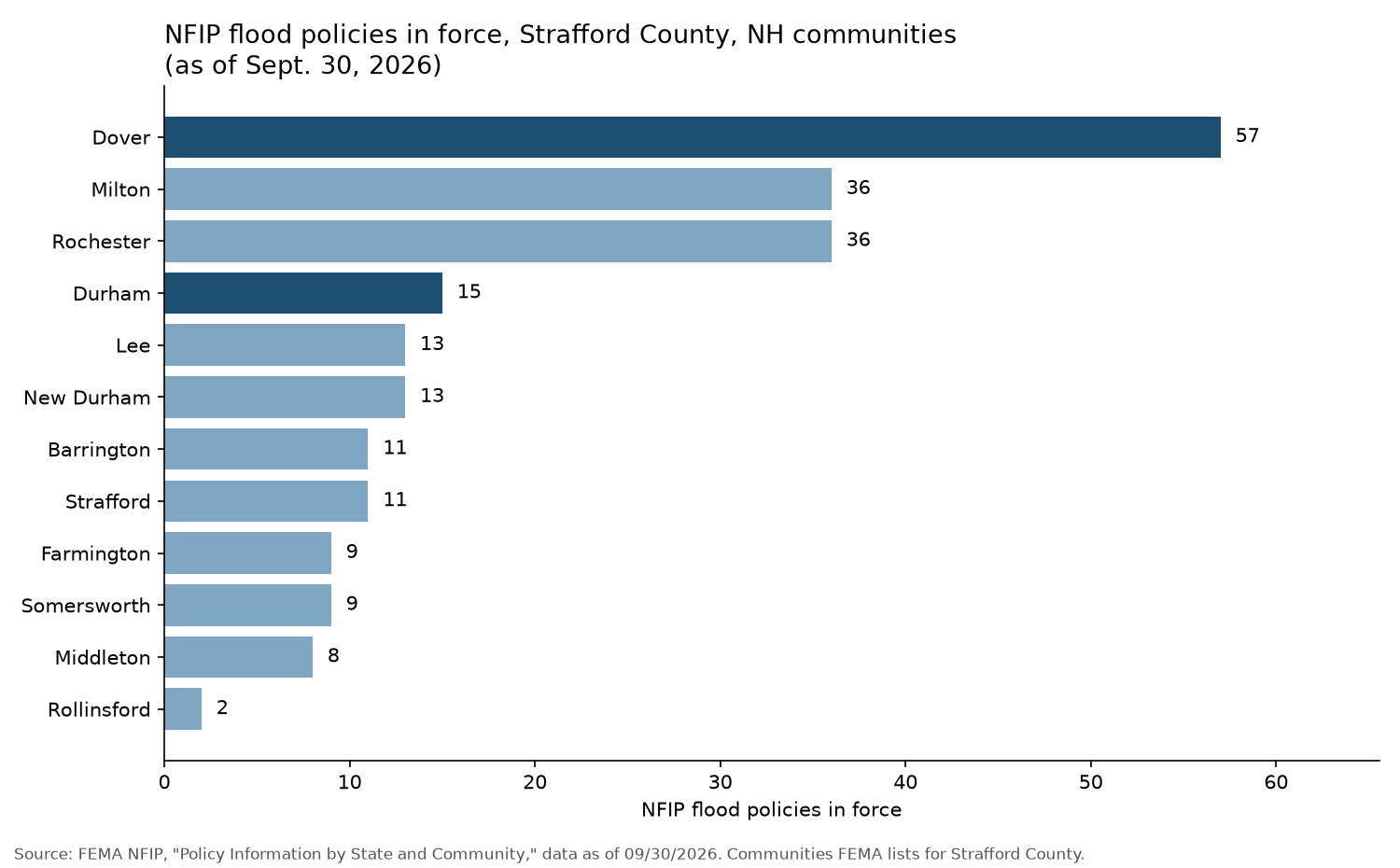
For comparison, the same report shows 163 in Portsmouth and 146 in Newmarket. Remember that a standard homeowners policy doesn’t cover flood damage.
Where can I get flood insurance in Dover or Durham?
We write NFIP policies through Selective, a write-your-own carrier for the federal program, and we also quote private flood carriers including Flow Flood, Neptune Flood, Beyond Floods, The Flood Insurance Agency, CatCoverage and Aon Edge. Some homes fit the NFIP better; others do better privately. If you have a mortgage, confirm your lender will accept a private policy first.
One more date to watch. As of October 14, 2026, Congress has authorized the NFIP only through December 11, 2026, according to FEMA. If that authorization lapses, FEMA stops selling and renewing policies until Congress acts. Our post on the December 11 flood insurance deadline explains what that means for NH owners.
Frequently asked questions
Are the new Strafford County flood maps in effect yet?
No. As of October 14, 2026, the maps are still preliminary. The appeal period began January 20, 2026, and FEMA sets an effective date only after appeals and comments are resolved. Until then, the 2015 maps remain the official ones.
Will I have to buy flood insurance if my home is newly mapped into a high-risk zone?
If you have a mortgage from a federally regulated or insured lender, yes. FEMA says your lender will require it once the new map takes effect and shows your building in a high-risk zone.
Is there a discount for newly mapped properties?
Yes. FEMA offers a Newly Mapped discount that can lower first-year premiums for buildings newly mapped into a high-risk zone, if you buy or renew within 12 months of the map change.
How can I see whether my property changes on the new map?
Search your address in FEMA’s Flood Map Changes Viewer, which compares the current and preliminary maps, or ask your town’s floodplain administrator.
Sources
- FEMA, “Public Invited to Appeal or Comment on Flood Maps in Strafford County, New Hampshire,” Feb. 6, 2026
- Federal Register, “Proposed Flood Hazard Determinations,” doc. 2025-20378, Nov. 20, 2025
- NH Office of Planning and Development, “Piscataqua-Salmon Falls Watershed” (checked Oct. 14, 2026)
- NH Office of Planning and Development, “Flood Lines” newsletter, Jan. 23, 2025
- FEMA NFIP, “Newly Mapped: A Discount for Properties Newly Designated in a SFHA,” Dec. 2025
- FEMA NFIP, “Risk Rating 2.0 Frequently Asked Questions”
- FEMA NFIP, “Policy Information by State and Community,” data as of Sept. 30, 2026
- FEMA, “Congressional Reauthorization for the National Flood Insurance Program” (updated Sept. 28, 2026)
By Jon Merwin, Founder and CEO
Portsmouth Atlantic Insurance is New Hampshire’s highest-rated agency on Google, with 1,000+ Google reviews and over 2,000 testimonials.
Related guides: Flood Insurance Deadline Dec. 11, 2026 · How to Choose the Right Homeowners Insurance in NH and CT · Protecting Coastal High-Value Homes in Rye, New Castle and Hampton
Next step: see our flood insurance options for New Hampshire homes.